|
Ocean
Currents-Lecture Notes
The study of ocean currents
is striking similar to meteorology, demonstrating the interconnectedness
of oceanic and atmospheric circulation. Like air masses in the
atmosphere, the movement of water masses shifts the heat balance for the
Earth. Also like air movement in the atmosphere, we will see that the
Coriolis Effect and density differences play the major roles in
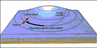
dictating the paths the water will travel. Large-Scale Currents Let's assume a simple closed ocean basin in the northern hemisphere. Our model ocean is bound on the south near the equator and at the north near the poles. Remember the "easterlies" near the equator? They push the surface water across the ocean from the eastern boundary to the western boundary. Meanwhile, the strong "westerlies" in the higher latitudes move the surface waters near the northern border of our ocean from the west to the east. Along the western and eastern borders, the waters move north and south, respectfully, to fill in the gaps left by the moving water. This sets up clockwise circular motion of the ocean. The poleward travelling current (western boundary current) will be warm, as the water has been warming up near the equator. The equator-travelling current (eastern boundary current) will be cold as the waters have been cooling in the high latitudes. On a smaller scale, along the edges of the currents the sharp boundary between the two water masses of different temperatures becomes irregular. This can cause the water of the current to spill out into the surrounding ocean, forming spiralling eddies. Because of the Coriolis Effect, we also need to keep in mind that the water will also be trying to deflect toward the right of the direction it is travelling. As you can see, that means the water will be moving toward the center of the ocean. This really occurs and the water forms a "hill" in the center of the ocean basins.
This hill may
only be several meters high-hardly noticeable-but it is high enough to
push the water back downhill under the influence of gravity. The result
is that the currents moving like a closed parade around the base of a
hill. The term for these closed loops of moving water in the oceans is a
GEOSTOPHIC GYRE. There are five gyres: North Pacific, South Pacific,
North Atlantic, South Atlantic, and Indian Ocean.
OTHER IMPORTANT SURFACE CURRENTS
…and the Equatorial Counter Current Eckman Spiral Generally speaking, the main currents of the gyres behave in the fashion explained above. But the winds only really drive the uppermost surface waters. Below this sheet of moving water, the next sheet feels the pull (via friction), but is deflected because of the Coriolis Effect (to the right in the northern hemisphere; left in the southern hemisphere). This sheet does not move as fast as the overlying sheet. Below it, the next sheet of water feels the pull of the overlying sheet, albeit not as strong, and moves. That sheet is also deflected due to the Coriolis Effect. We can therefore think of the water in these currents as a stack of sheets, about 100 meters thick total. Going down in the water column, the sheets are systematically deflected, and moving slower. In fact, the sheet at the bottom is moving in the opposite direction to the sheet at the top! By adding up the vectors (direction and speed of travel) of the sheets, based on the mathematical models, we come up with an average of about 90º deflection from the direction the wind is blowing. However, the hill of water, described above, reduces the deflection to about 45º.
Countercurrents and High-Latitude Currents Some currents flow in
directions opposite what we would think based on wind directions and the
Coriolis Effect. The piling of water from the moving surface currents
causes backflow. This back flow can occur at the surface, such as seen
near the equator between the north and south equatorial currents. Or,
the backflow can occur below the major current. In cross-section, the
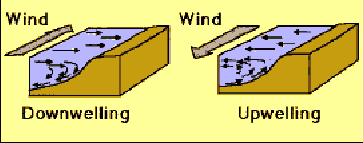
water mass would appear like a two-story bridge. Vertical Currents Water also moves up and down as well as along the surface. The most common movement occurs where surface waters move away from each other or converge upon each other. In the first case, as surface waters move away, the water underneath (typically colder and more nutrient-rich) moves up to fill in the gap. This is called UPWELLING. In the other case, when surface currents converge, the excess warm water is forced down, causing DOWNWELLING. Both of these situations also occur along coastlines when prevailing winds push the water away from the coast (causing upwelling) or toward the coast (causing downwelling). Notice that the surface currents are moving perpendicular to the wind direction. This is due to the Coriolis Effect. Which hemisphere is this picture modeled after?
Movements of waters below the surface As you recall, the ocean is stratified due to density-in itself, a function of temperature and salinity. Within each of the three main water masses (surface water, pycnocline, deep water), currents are established and the water circulates. We have already discussed surface circulation. Another important current is the one that contains the densest waters in the ocean (due to cold temperatures and high salinity). These waters begin in the polar regions where the formation of ice increases the density of the remaining oceanic water. The cold, salty water sinks and flows along the bottom toward the equator. These bottom currents flow much slower than the surface currents, but are very important in moving nutrients around the globe. Also, these currents cause erosion and rippling of the deep sea sediments. Because these currents tend to flow around, and not over highs on the sea floor, we call them "contour currents." The largest bottom current, the Antarctic Bottom Water, begins at Antarctica and flows all the way to the Aluetian Islands and northern Atlantic Ocean! A similar current sinks off of Greenland and moves south in the Atlantic, called the North Atlantic Deep Water. Finally, a peculiar mass of very salty water flows out of the Mediterranean and onto the Atlantic seafloor, called the Mediterranean Deep Water. Because it is warmer, the Mediterranean Deep Water flows over the other bottom currents. In other cases, waters of similar density, but different temperature and/or salinity mix and form a more dense water mass through a process called "caballing." These density currents, and others like it, form the "thermohaline circulation patterns."
Climate At the beginning of these
lecture notes, I alluded to the interconnections between oceanic
circulation and climate. There are many, many complex ways in which the
oceans influence climate, but one general rule applies: the long-travelling
ocean currents move stored heat from one area to another. The air masses
over these currents become warmer or cooler, depending on the
temperature of the water. The classic example is how the Gulf Stream
brings a mass of warm water up into the Northern Atlantic and mediates
the potentially bitter winters in Europe. Another example we already
discussed is how the shift in warm water from west to east across the
Pacific can have devastating changes to global weather patterns (El
Nino). 1. The primary mover of surface waters is the WIND 2. Water masses move away from high pressure zones and toward low pressure zones. 3. Dense water sinks and less dense water rises 4. Geostrophic gyres are large-scale, closed circuits of moving water (currents). 5. The gyres consist of two transverse currents, a western and an eastern boundary current. Western boundary currents are warm, fast, and have sharp boundaries. Eastern boundary currents are cold, slower, and have diffuse boundaries. 6. "Hills" of water are piled up in the centers of the gyres. These hills are offset to the west due to the rotation of the Earth. 7. .The "Antarctic Circumpolar Current" or "ACC" is a large current which is driven unimpeded by the strong westerlies in the high latitudes of the southern hemisphere, encircling Antarctica, passing through the Drake Passage 8. The Eckman Spiral is a representation of how horizontal sheets of moving water are systematically deflected, and move slower as one goes down in the water column. Because of the hill in the center of the gyres, the average water flow is offset 45 degrees to the direction of wind travel. 9. Smaller currents also flow in the opposite direction within or under larger currents. These are called "countercurrents" or "undercurrents", respectively. 10. When surface waters move away from each other, vertical currents upwell. When surface waters converge upon each other, vertical currents downwell. Both of these situations occur along coastlines when prevailing winds push the water away from the coast (causing upwelling) or toward the coast (causing downwelling). 11. Dense, bottom currents, also called "contour currents", begin in the polar regions where the formation of ice increases the oceanic water density. The cold, salty water sinks and flows along the bottom toward the equator. These bottom currents flow much slower than the surface currents, but are very important in moving nutrients around the globe. Two important bottom currents are the Antarctic Bottom Water and the North Atlantic Deep Water. 12. The Mediterranean Deep Water is a warmer deep current whose high density is a function of increased salinity. 13. Oceans influence climate by moving warm and cold water about the planet. This changes the temperature of the air masses passing over. WWW Sites: http://marine.rutgers.edu/mrs/upwelling.html http://daac.gsfc.nasa.gov/CAMPAIGN_DOCS/OCDST/ocdst_upwelling_dynamics.html http://lola.ldgo.columbia.edu/SOURCES/.EPCU/.dataset_documentation.html http://www.seaspace.com/images/calif.jpg http://www.seaspace.com/images/kuroshio.jpg http://www.pmel.noaa.gov/ http://www.vol.it/MIRROR4/EN/knot.met.nps.navy.mil/pub/braccio/WOCE/mpeg.html http://www.mth.uea.ac.uk/ocean/fram.html In addition, look at previous sites for more information dealing with currents.
|
Transferred from : http://online.redwoods.cc.ca.us/instruct/RShapiro/Ocean10/lectures/currents.htm
